

Pavement Ends
James Baughn was the webmaster of seMissourian.com and its sister newspapers for 20 years. On the side, he maintained even more sites, including Bridgehunter.com, LandmarkHunter.com, TheCapeRock.com, and Humorix. Baughn passed away in 2020 while doing one of the things he loved most: hiking in Southeast Missouri. Here is an archive of his writing about hiking and nature in our area.
-
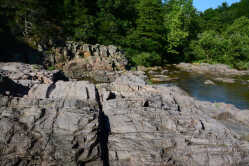
The Pavement Ends guide to the Ozark Riverways
Posted Wednesday, August 19, 2020, at 8:00 AMThe word "vacation" has certainly taken on a different meaning in the middle of a pandemic. Long-distance travel has turned into a huge ordeal, so it makes sense to seek out vacation spots that are closer to home. Meanwhile, everybody else is thinking the same thing. So getting away from it all may not actually result in getting away from it all... -

Maintz sunflowers back for 2020
Posted Monday, July 27, 2020, at 2:56 PMThe sunflowers are now in full bloom at Maintz Wildlife Preserve in Cape Girardeau County. In most years they tend to peak around July 4th, but this year they are slightly behind schedule... -
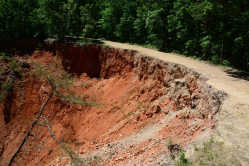
Massive sinkhole opens in Reynolds County along the Trail of Tears
Posted Wednesday, June 3, 2020, at 10:20 AM1Warning: The location featured here is more hazardous than the usual "Pavement Ends" destination. We're not responsible if you venture too close to the edge and get walloped by gravity. The precipice of a growing sinkhole is not your friend... -
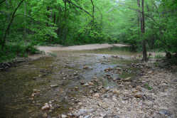
Hike from 0 to 12 miles on the Audubon Trail
Posted Thursday, May 14, 2020, at 9:28 AMThe region between Fredericktown and Perryville is a geographic oddity. Five counties -- Ste. Genevieve, Perry, Bollinger, Madison, and St. Francois -- converge in this area with weirdly-shaped boundaries. The peculiar W-shaped line between Ste. Genevieve and St. Francois County even led to a boundary dispute in 2002... -
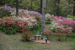
Scenes from Pinecrest Azalea Garden
Posted Sunday, April 19, 2020, at 9:13 PMThe azaleas are close to their peak at Pinecrest Azalea Garden near Oak Ridge. The spacious garden is a great place to get some fresh air while still maintaining social distancing. The proprietors have even provided picnic tables with paper towels and cleaning bottles... -
Ideas for getting away from it all
Posted Friday, March 27, 2020, at 2:29 PM1Sick of being stuck at home where the only excitement today was when your cat coughed up a hairball? Tired of the constant political bickering about the pandemic on Facebook? Going outside for a mental health break is fine as long as you practice that social distancing we've heard so much about... -

Jean Dale: Cape Girardeau baseball sensation (with an asterisk)
Posted Monday, February 10, 2020, at 5:30 PMNote: The history stories that appear in the newspaper on Sundays are limited to 500 words. This is an unabridged version of the Jean Dale story which adds more background and includes hyperlinks to additional sources... -
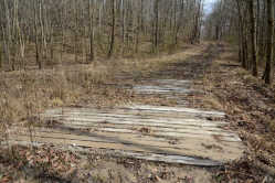
Hike a modern-day version of a plank road
Posted Thursday, December 19, 2019, at 8:49 PMThe 1850s brought a short-lived innovation to Southeast Missouri and Southern Illinois: plank roads. By building roads with timber planks elevated above the ground, wagons could pass easily without getting stuck in the mud. In 1851, construction work started on the Ste. Genevieve, Iron Mountain and Pilot Knob Plank Road. This toll road, built with planks 8 feet long and 2 inches thick, provided an important connection between the mines at Arcadia Valley with the Mississippi River... -

Scenes from the 2019 Christmas Country Church Tour
Posted Saturday, December 14, 2019, at 3:01 PMThis year's Christmas Country Church Tour was larger than ever, featuring 38 stops across five counties. The event is now "interstate" since it includes the church in Kaskaskia, located in Illinois but accessed from Missouri... -
How to get your own Griswold Family Christmas Tree
Posted Wednesday, December 11, 2019, at 10:40 PM1New for 2019, the Shawnee National Forest in Illinois is offering a $5 permit to cut down the Christmas tree of your choice from forest lands. Some restrictions apply, of course... -

Joseph McFerron: court clerk, duel winner... and poet?
Posted Wednesday, July 3, 2019, at 7:10 PMLocal historians are well acquainted with Joseph McFerron, the first clerk for the courts of the Cape Girardeau District, since he left behind a mountain of documents penned in his distinctive handwriting. He's also known for the 1807 duel in which he shot and killed William Ogle... -
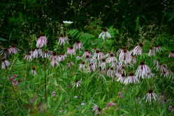
See the bonus coneflowers at Royal Gorge
Posted Monday, June 17, 2019, at 9:00 AMI've written previously about the stand of pale purple coneflowers at Cave Creek Glade Nature Preserve near Vienna, Illinois. This weekend I found another place to see coneflowers, this time in Missouri along Highway 21/72 at Royal Gorge in Iron County... -
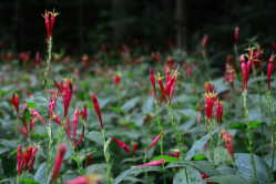
Dixon Springs putting on a show of Indian pink wildflowers
Posted Wednesday, June 12, 2019, at 9:00 AMThe Ghost Dance Canyon Trail at Dixon Springs State Park in Illinois is an excellent destination in all four seasons... -
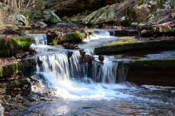
Wet weather is the best time to visit Ferne Clyffe State Park
Posted Thursday, April 25, 2019, at 11:00 AMApril showers are a good thing! Not only do they bring May flowers, but heavy rainstorms produce an abundance of waterfalls. Although the trails might be choked with mud, if you want to see waterfalls at their peak, then mud is a small price to pay... -
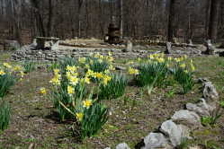
Spring photography ideas in Cape Girardeau County
Posted Friday, March 29, 2019, at 5:36 PM4The daffodils have bloomed and the magnolia and pear trees are at their best. We've finally made it to spring. Here are some ideas for places to visit in Cape Girardeau County to capture the all-too-brief spring colors. Boulevard Historic District... -

Fallen tree branch damages headstones at Old Lorimier Cemetery
Posted Thursday, March 21, 2019, at 1:51 PMOur recent windstorm seems to have done a number on a tree at Old Lorimier Cemetery in Cape Girardeau. A large branch from an ancient hackberry tree has fallen across several headstones... -

Bald eagles putting on a show near Big Muddy River in Illinois
Posted Monday, March 18, 2019, at 1:58 PMThis last weekend saw a large crowd descend on the Snake Road at LaRue-Pine Hills in Illinois to watch the snake migration. For those of us not interested in reptiles, the same area is currently offering another kind of wildlife viewing opportunity: bald eagles... -
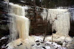
Suggested places to see the ice
Posted Tuesday, January 29, 2019, at 3:36 PMWe may not always get a big snow in the winter, but it does seem that the "Polar Vortex" always makes at least one appearance. These Arctic blasts do offer one advantage: ice formations... -

Suggested places to visit in the snow
Posted Thursday, January 17, 2019, at 5:50 PMOne of these days we'll finally get a decent snowfall instead of watching the systems miss us to the north or south. When that happens, here are some ideas for scenic places to visit to enjoy a winter wonderland... -
"Blown into atoms": An account of the tornado of 1850
Posted Monday, November 26, 2018, at 9:00 AM1Sharon Sanders recently posted several accounts of the destructive tornado that ripped through Cape Girardeau on Nov. 27, 1850. In the weeks following the disaster, newspapers across the country published stories about the tornado (or "hurricane"), although the details varied widely. ...
View all blog posts (423)
Trip Planner
