

Pavement Ends
James Baughn was the webmaster of seMissourian.com and its sister newspapers for 20 years. On the side, he maintained even more sites, including Bridgehunter.com, LandmarkHunter.com, TheCapeRock.com, and Humorix. Baughn passed away in 2020 while doing one of the things he loved most: hiking in Southeast Missouri. Here is an archive of his writing about hiking and nature in our area.
- Email link
- Post comment
- Share:


Hike a modern-day version of a plank road
Posted Thursday, December 19, 2019, at 8:49 PM
The 1850s brought a short-lived innovation to Southeast Missouri and Southern Illinois: plank roads. By building roads with timber planks elevated above the ground, wagons could pass easily without getting stuck in the mud.
In 1851, construction work started on the Ste. Genevieve, Iron Mountain and Pilot Knob Plank Road. This toll road, built with planks 8 feet long and 2 inches thick, provided an important connection between the mines at Arcadia Valley with the Mississippi River.
On the other side of the river, the Randolph County Plank Road was completed in 1854 between Chester and Sparta, Illinois. The covered bridge over Little Mary's River is a remnant from this project.
A more elaborate plank road was built in the Missouri Bootheel. Constructed in the 1850s by the Dunklin and Pemiscot Road Company, this road was said to have 146 wooden bridges in order to cross the swamps. After the Civil War, it was rebuilt in 1873 and known as the Pole Road.
The coming of the railroad marked the end of the plank road era. The backers of the Ste. Genevieve plank road, in particular, lost their shirts when the Iron Mountain Railroad reached the Arcadia Valley in 1858.
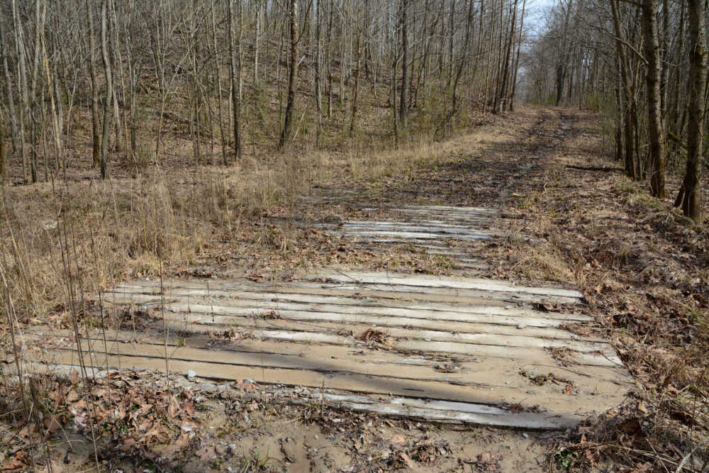
Little remains from these plank roads, but you can get a taste for how they worked by hiking along National Forest Road 741 northwest of Pomona, Illinois. A few years ago, the road was improved by utility workers to provide temporary access to a power line corridor. To avoid getting their equipment stuck in the mud, they installed sections of timber planks laid on the ground.
Nature is quickly reclaiming the road surface, but enough timber planks remain to help hikers stay out of the mud.

The road itself follows the base of a modest line of sandstone bluffs.

In wet weather, a small waterfall can be found in a side canyon to the north of the road. It pays to keep your ears open for the sound of running water, which is how I've found this and other waterfalls.

Beyond the waterfall, the creek continues uphill through a valley, leading to a second falls.

This is a fun area to explore, dotted with hidden rock formations, small waterfalls... and a throwback to 1850s road-building technology.
Directions
The address for the trailhead is 3450 Hickory Ridge Road, Pomona, IL (or GPS coordinates 37.6593755, -89.3722973).
From Cape Girardeau, cross the Emerson Bridge and turn left (north) on Highway 3. At Ware, turn right on Highway 146. Then turn left at Highway 127 and drive to Alto Pass. After going under the overpass at Alto Pass, make two right turns to go across the overpass.
Continue on this road, Milligan Hill Road, for 4 miles. The road comes to a T-junction with Sadler Road and Jerusalem Hill Road. Bear left and continue on Jerusalem Hill Road for 1 mile. Turn left on Hickory Ridge Road in front of Jerusalem Church. Then follow Hickory Ridge Road for 3.5 miles. Just after the bridge across Cedar Creek, the blacktop road curves left, while a gated forest road heads to the right. Park where convenient away from the blacktop.
Hike east along the forest road for a quarter-mile to come to a creek crossing and a section of wooden planks. From here, you can walk to the northwest along the side canyon to reach the lower waterfall at coordinates 37.661349, -89.369089. The upper falls can be found by bushwhacking up the creek to 37.663318, -89.371677. Back on the plank road, you can continue to the southeast until the road peters out at the power line clearing.
- Email link
- Post comment
- Share:
Trip Planner

Respond to this blog
Posting a comment requires a subscription.