

Pavement Ends
James Baughn was the webmaster of seMissourian.com and its sister newspapers for 20 years. On the side, he maintained even more sites, including Bridgehunter.com, LandmarkHunter.com, TheCapeRock.com, and Humorix. Baughn passed away in 2020 while doing one of the things he loved most: hiking in Southeast Missouri. Here is an archive of his writing about hiking and nature in our area.
- Email link
- Read comments (2)
- Share:


A secret place in Wayne County
Posted Wednesday, June 11, 2008, at 11:48 AM
It's hard to beat the excitement of standing in front of a trailhead with absolutely no idea what lies ahead. That was the case last fall when I found myself on a Wayne County backroad riding with a dog who was getting rather anxious and wanted to go for a W-A-L-K.
I happened to find a parking area marked with one of those yellow "Missouri Department of Conservation -- Welcome" signs. This was the perfect place to let Shelby The Yellow Dog stretch her legs before she drove me crazy.
She wasted no time pulling me down the trail. It was a boring walk at first through some woods. I knew that the trail probably led down to the St. Francis River, but I didn't look at my maps when I started out from the parking lot (it's more fun this way).
I never did reach the river because, after a short quarter-mile hike, I stumbled across something far more interesting:
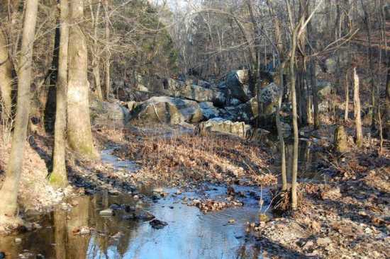
It's a rocky shut-ins along a tiny, unnamed tributary of St. Francis River. The trail actually bypasses the shut-ins, but I heard the distinctive sound of water and knew that I had to explore.

Shelby was quite eager to show off her climbing skills. (She once climbed Tower Rock on her own. Getting her back down was a bit of a challenge, though.)

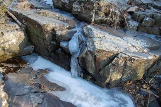
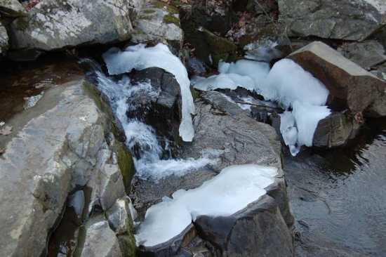
This is a very "cool" place. I mean that literally, as this is a shady location. In winter, the creek water freezes into curious ice formations:
Oddly enough, the shut-ins empty straight into the floodplain of the St. Francis River (and the upper reaches of Lake Wappapello). It's completely flat just below here.

There's not enough water to make this a swimming hole in the summer. Nevertheless, this small but impressive shut-ins is a "cool" destination in any season. With a convenient parking area just two miles from Highway 34 and a short, easy trail, it's surprising this place isn't better known. It doesn't even appear to have a name.
Driving directions
From Cape Girardeau, take Highway 34 west through Jackson, Marble Hill, and Silva. Navigate through the crazy intersections with U.S. 67 at Silva and continue on Highway 34 West. Roughly one mile later, keep your eyes peeled for Rebel Cave Road (County Road 310) on the right. This is old Highway 34 and the pavement is terrible. But it doesn't last long, as you will veer right on County Road 311 after only a half mile. This is a decent gravel road. It runs north for one mile and then turns sharply to the left for another half mile. Look for the Conservation Area signs and parking lot on the left as the road enters into the woods. Take the trail for a quarter mile and look for the shut-ins at the bottom of the small valley to the left.
Quick facts
What: Shut-ins along an unnamed creek near Logan Mountain
Where: Wayne County, Missouri, northeast of Patterson
Owner: U.S. Army Corps of Engineers, leased to Missouri Department of Conservation as part of Wappapello Lake Management Lands
GPS coordinates: +37.20669, -90.49822
Topographic map: Greenville
- Email link
- Read comments (2)
- Share:
Trip Planner

Respond to this blog
Posting a comment requires a subscription.