

Pavement Ends
James Baughn was the webmaster of seMissourian.com and its sister newspapers for 20 years. On the side, he maintained even more sites, including Bridgehunter.com, LandmarkHunter.com, TheCapeRock.com, and Humorix. Baughn passed away in 2020 while doing one of the things he loved most: hiking in Southeast Missouri. Here is an archive of his writing about hiking and nature in our area.
- Email link
- Post comment
- Share:


Piney Creek Ravine has prehistoric rock art (and modern graffiti)
Posted Tuesday, November 6, 2007, at 10:17 AM
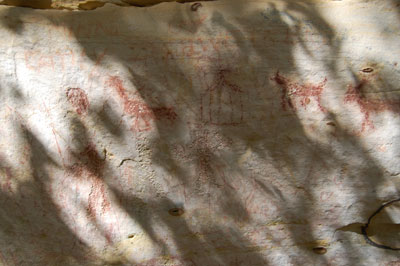
A secluded rock wall east of Chester, Illinois, is the setting for the largest collection of Native American rock art in Illinois. It's also home to an extensive collection of graffiti from more recent times.
The sandstone shelter at Piney Creek contains 200 documented examples of rock art, including petroglyphs (carvings) and pictographs (paintings). An interpretive sign next to the wall explains that the designs likely originated from the Late Woodland (A.D. 500-1000) and Mississippian (A.D. 1000-1550) periods.

(This sandstone shelter protects the rock art.)

(An example of some of the better preserved petroglyphs)
However, the prehistoric art is difficult to see. It's overshadowed by all of the names carved into the rock from the late 1800s and 1900s.

(Settlers from 1878 couldn't resist carving their names into the rock)

(This Masonic symbol was etched in 1913)
The graffiti presents somewhat of a quandry, however, because some of it is old enough to be considered historically significant in its own right. But it clearly detracts from the much more valuable prehistoric art.
(Some people have tried to "enhance" the rock art by outlining it with paint or chalk. Bad idea!)
Signs all along the trail warn against vandalism. But the damage has already been done.
While the rock art is no longer pristine, the rest of Piney Creek Ravine is relatively unspoiled. Managed as a State Natural Area, this nature preserve also features a beautiful sampling of the sandstone bluffs, canyons, waterfalls, and shelters that are found throughout Southern Illinois.
A two-mile trail loops around the ravine, but many visitors choose to scramble up and down Piney Creek.

(A bluff along the lower part of the creek. Notice how the layers of rock have eroded at different rates.)
The creek alternates between gravel and solid rock bottoms. Where the water encounters solid sandstone, it has carved a narrow crevice through the rock.

In other places, the water simply tumbles over shallow ledges.

And in one place along an unnamed tributary of Piney Creek, a trickle of water suddenly drops over a ledge into a canyon at least 20 feet below. Watch your step:

Featuring both man-made art and natural beauty, Piney Creek Ravine is an excellent choice for a weekend afternoon outing in Southern Illinois.
Driving directions
From Cape Girardeau, take Highway 146 across the river and then turn left on Highway 3. Stay on Highway 3 for roughly 46 miles until you reach the turnoff for Hog Hill Road on the right. (This turnoff is located a few miles after the intersection with Highway 151. If you reach the town of Rockwood, you've gone too far.)
Continue on Hog Hill Road for a few miles until the intersection with Degognia Road. Here, make a right turn, and then bear left on to Rock Crusher Road. After another mile, make a sharp left turn on Piney Creek Road (look for the natural area sign). A short distance after this road turns to gravel, look for a sharp left curve. The parking area and trailhead is located to the right.
It's also possible to approach from Chester, taking Murphysboro Road out of town (See Google map). This road becomes County Farm Road. Follow it for approx. 9 miles until you reach Piney Creek Road on the right. This last road is a very narrow gravel lane and is rather treacherous.
Quick facts
Name: Piney Creek Ravine State Natural Area
What's here: Rock art, canyons, waterfalls
Claim to fame: Largest collection of prehistoric rock art in Illinois
Location: Randolph County, Illinois, just northwest of the Jackson County line
Owner: Illinois Department of Natural Resources (198 acres acquired 1972)
GPS coordinates: +37.89642, -89.63681 (approx. location of rock art); +37.89053, -89.63827 (parking lot and trailhead)
Topographic quadrangle map: Welge
Websites: Illinois DNR
- Email link
- Post comment
- Share:
Trip Planner

Respond to this blog
Posting a comment requires a subscription.