

Pavement Ends
James Baughn was the webmaster of seMissourian.com and its sister newspapers for 20 years. On the side, he maintained even more sites, including Bridgehunter.com, LandmarkHunter.com, TheCapeRock.com, and Humorix. Baughn passed away in 2020 while doing one of the things he loved most: hiking in Southeast Missouri. Here is an archive of his writing about hiking and nature in our area.
- Email link
- Read comments (3)
- Share:


Artificial scenery
Posted Tuesday, August 28, 2007, at 12:42 PM
Can you guess where this photo was taken?

Is it a mountain stream in Colorado? An Ozark shut-ins?
Nope.
It's the Block Hole in Cape Girardeau County, a man-made flood control structure along the Diversion Channel. Water diverted from Castor River tumbles over a series of rocks and into a large hole:

Looking upstream along the Diversion Channel

Looking downstream at the Block Hole basin
The Missouri Department of Conservation leases 10 acres to provide a boat ramp and public fishing access to the Block Hole and Diversion Channel. Even if you don't have any interest in fishing, this is still a unique place to visit, featuring a cascading stream and large boulders to scramble across.
If you squint your eyes, you can almost pretend this is a clear, rushing mountain stream. But the whole scene is artificial. The Diversion Channel is a man-made river designed to capture water from Castor River, Crooked Creek, Whitewater River, Hubble Creek, and other tributaries, and send the water directly to the Mississippi River. This keeps the water from overflowing into the flat lands of "Swampeast Missouri."
The problem with the Diversion Channel, however, is that it allowed water to move the other direction when the Mississippi River was at a high river stage. A wall of blocks, called a weir, was constructed 11 miles upstream from the Mississippi to prevent river water from backing up too far along the channel. The weir also prevented the upper portion of the Diversion Channel from eroding down to level of the Mississippi.
Over time, the water flowing over the weir carved out a large, circular basin -- the Block Hole. That's what we have today.
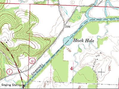
The Block Hole is clearly shown as a circular pool of water on topographic maps. The Diversion Channel meets Whitewater River just northeast of here.
In 2003, the U.S. Army Corps of Engineers performed extensive work to stabilize the area, bringing in large quantities of rip rap. The following year, the Conservation Department built a boat ramp and parking lot.
Driving directions
1. From Cape Girardeau, take Highway 74 west to Dutchtown and turn left at the stoplight.
2. Follow Highway 25 to Delta.
3. Turn right on Route N and continue until you reach the intersection with Route U and T (the so-called "NUT Junction")
4. Make a right on Route U and look for the Block Hole Access sign and parking lot on the right.
Facts
Name: Block Hole
What: Flood control structure along the Castor River Diversion Channel, featuring cascades and a deep pool
Location: Southwest of Whitewater, Cape Girardeau County, Missouri
GPS coordinates: 37.213108, -89.840372
Topographic quadrangle: Whitewater
Owner: Little River Drainage District, leased to the Missouri Department of Conservation
Website links: Missouri Conservation Atlas, History of the Little River Drainage District, Column by Joe Sullivan
- Email link
- Read comments (3)
- Share:
Trip Planner

Respond to this blog
Posting a comment requires a subscription.