
- -30- then and now (8/22/18)2
- Meet Mable at Mable's Cafe in Chaffee (8/20/18)
- Willow Grove Rockets Skate Club (8/15/18)
- Central Municipal Pool built in 1979 (8/13/18)
- Hecht's Store founder returns to Main street (8/8/18)
- Land acquired to build SEMO Port (8/6/18)
- St. Vincent's Seminary ends after 136 years (8/1/18)1
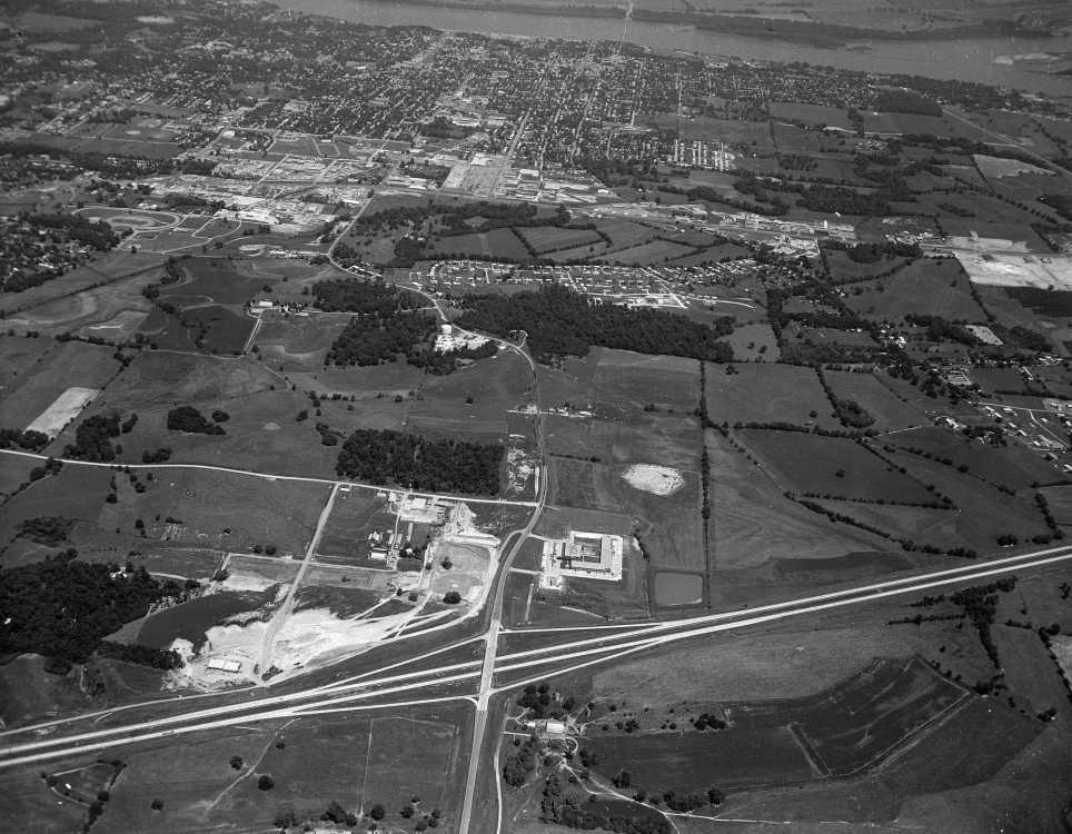
This aerial photograph by G.D. Fronabarger shows the west side of Cape Girardeau in the early 1960s. The Town Plaza, which opened in 1960, is visible in the upper middle of the photo. The Mississippi River is visible at the top. Interstate 55 is at the bottom of the photo.

The Holiday Inn is visible in the photo above, at right, and in the photo below, above Interstate 55. Holiday Inn was constructed in 1962 and held a grand opening in May, 1963. The Ramada Inn would be built a few years later, opening in 1969, north of Holiday Inn.

Gordonville Road curves to the west from Independence in the center of the photo.

This section shows the area where Independence street will later be extended to Mount Auburn road, which runs along the bottom of the photo.

The Schonhoff Dairy farm is visible in the center with the National Guard armory above it, next to the intersection of Independence street and Gordonville Road.

The Earl Siemers farm just west of Interstate 55 would become commercial development with properties built along Siemers Drive. Among them would be Wal-Mart, motels, car dealerships, restaurants and various retail stores.
Respond to this blog
Posting a comment requires a subscription.