*
f/8 and Be There
Fred Lynch

Wharf parking to end

Posted Friday, March 5, 2010, at 7:30 AM

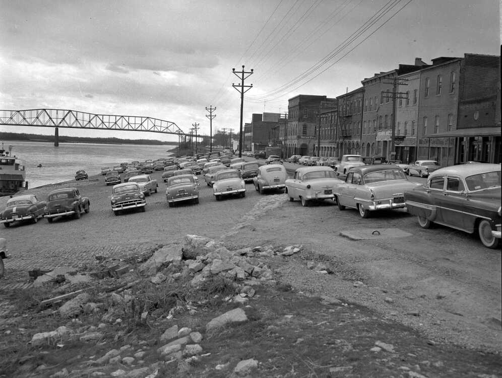
Southeast Missourian, March 21, 1956:

Wharf parking poses problem; area soon will be closed to vehicles

Despite its cobblestone surface, its slant and the obvious danger, the Mississippi River wharf at the foot of Broadway and Themis street is used extensively for parking, especially by store owners and clerks in the Main street business area. The picture showing vehicles on the wharf is representative of the situation almost any day.

Soon, however, this area will be closed to parking. Within a few weeks construction of a new sewer line running along Water street from Broadway to Independence street will be started as a part of the flood control project now underway. When this work starts, it will be impossible for vehicles to cross Water street to reach the wharf area.

The question then is where will the vehicles which normally park on the wharf be left? The problem is one for the merchants in the area and of the city administration.

Although some temporary relief may be found, actually the problem must be solved on a permanent basis, since the flood control plan calls for a concrete wall to run along Water street, thus closing the wharf area to use entirely.

(Photo by G.D. Fronabarger)

Comments

View 8 comments or respond
Community discussion is important, and we encourage you to participate as a reader and commenter. Click here to see our Guidelines. We also encourage registered users to let us know if they see something inappropriate on our site. You can do that by clicking "Report Comment" below.
  • When was the levee built?

    -- Posted by bobby62914 on Fri, Mar 5, 2010, at 8:02 AM
  • That is an awesome picture...any way to get a larger print of that?

    -- Posted by capeeats on Fri, Mar 5, 2010, at 8:22 AM
    Fred Lynch
    Reprints are available of pictures by G.D. Fronabarger by contacting me at flynch@semissourian.com.
  • The levy was built 1960 era + or - a year or two. Huge objections from some businessmen.

    -- Posted by Yankee Station on Fri, Mar 5, 2010, at 11:51 AM
  • I would've thought it was built much earlier. This photo disabused me of that notion...

    -- Posted by bobby62914 on Fri, Mar 5, 2010, at 12:46 PM
  • So that's where all the parking has gone...Instead of tearing down Broadway buildings for parking, y'all ought to look at how it used to be done.

    -- Posted by jacksonjazzman on Fri, Mar 5, 2010, at 1:03 PM
  • Fred,

    I remember when it was common to park on the riverfront (and what would happen when someone would forget to set the parking brake).

    Here are some aerial photos of downtown Cape after the floodwall was built and before the wharf area had been restored.

    http://www.capecentralhigh.com/cape-photos/downtown-cape-girardeau-aerial-photos...

    It shows a lot of vintage and now-missing Cape landmarks. There's a shot peeping over the floodwall that has Al's Shops, Woolworths, J C. Penney's, Montgomery Wards, Firestone and the St. Charles Hotel in it.

    See the sign that was on Highway 61 between Cape and Jackson touting rooms in the St. Charles for $1.50 and up (with electric fans, no less).

    -- Posted by ksteinhoff on Sat, Mar 6, 2010, at 12:40 PM
  • You know, for a city boy like me from Chicago, it's nice to know that there are other parts of the country with rich history.

    Just glad I can peek into Cape's every once in a while.

    -- Posted by vincebrown on Sun, Mar 7, 2010, at 1:02 PM
  • Fred,Do you have any pictures north from Broadway and Water Streets, showing the Sand Plant before the flood wall was built? The flood wall ended that business, and I can remember a concrete structure besides the tracks that they used to load sand and gravel into trucks. That building was left standing into the 70's after I moved from this area, and I've now returned.

    -- Posted by billsheppard52@gmail.com on Mon, Apr 11, 2011, at 7:57 AM