

Pavement Ends
James Baughn was the webmaster of seMissourian.com and its sister newspapers for 20 years. On the side, he maintained even more sites, including Bridgehunter.com, LandmarkHunter.com, TheCapeRock.com, and Humorix. Baughn passed away in 2020 while doing one of the things he loved most: hiking in Southeast Missouri. Here is an archive of his writing about hiking and nature in our area.
- Email link
- Read comments (2)
- Share:


Not Your Town: Point Rest, Missouri
Posted Monday, April 14, 2008, at 5:49 PM
The name Point Rest, found on maps of Perry County, definitely lives up to its name. It's very restful. In fact, there's absolutely nothing here except a levee and a couple gravel roads.

Point Rest was never very big, but it did have a post office (from 1891-1940), a store, and a river landing. However, floods along the Mississippi, especially in 1927, took their toll on Point Rest and many other settlements in Perry County.
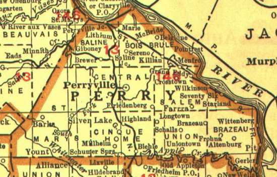
This map from a 1920s Rand McNally atlas shows many names along the river that no longer exist: Marie, Grand Eddy, Killian, Wilkinson, Seventy Six, Starland, Pit, and Gerler. Older maps from the late 1800s show even more placenames. Meanwhile, towns such as Wittenberg, Belgique, and Claryville were prosperous at one time but are hanging on by a thread today.
The flatland along the river opposite Chester, Illinois, is known as the Bois Brule Bottom, from the French phrase for "burned woods." Surrounded by tall hills on both sides, it's quite a scenic area.

When I visited on April 5, the henbit was on full display in the fields. Henbit is a weed, but it's a pretty weed.

The Bois Brule Levee surrounds the area, protecting it from the Mississippi River and its tributaries, Cinque Hommes Creek and Bois Brule Creek. A gravel road runs the length of the levee, making for a nice drive on a sunny spring day.

At the southern end of the Bois Brule, it's still possible to see the damage caused by the Sept. 22, 2006, tornado that ripped through Crosstown before heading across the Mississippi. The twister destroyed trees along entire hillsides.

If you take the levee road to the north, toward Chester, you will suddenly enter into Illinois -- without crossing a single bridge. A small piece of Illinois now sits on the Missouri side of the river at a place called Crains Island. The river shifted course since the state lines were surveyed, leaving a piece of Randolph County, Illinois, on the "wrong" side.
In this photo, the foreground is part of Missouri while the background is Illinois. At least, that's what my maps show -- there's absolutely no indication of the border crossing from the road.

The topographic map of the area is quite strange. I'm not sure how a state line could have an "indefinite boundary" on dry land, but that's what happens here.

Similar border anomolies, known as "avulsions," can be found all along the Mississippi River, with the most well-known located at Kaskaskia, Illinois. I'll have more on these in future blogs.
Driving directions
From Cape Girardeau, take Highway 61 north to Perryville. Just after reaching the city limits, turn right on Route E (Allens Landing Road) and follow it for several miles until you cross Bois Brule Creek and the railroad tracks. Here the road meets the levee, with the Bois Brule Bottom on the other side. You can explore in any direction -- left, right, or straight -- but I'd suggest turning right on the levee road (marked as County Road 354 here) and following it for as many miles as you want to drive. This will take you to Menfro, followed by the southern tip of the floodplain, and then back around to the north before reaching Point Rest (or what's left of it). [Google map]
You can also reach the Bois Brule by taking Route C from Fruitland to Menfro via Altenburg. Highway 51 from Perryville toward Chester is another option, but not quite as interesting.
- Email link
- Read comments (2)
- Share:
Trip Planner

Respond to this blog
Posting a comment requires a subscription.