

Pavement Ends
James Baughn was the webmaster of seMissourian.com and its sister newspapers for 20 years. On the side, he maintained even more sites, including Bridgehunter.com, LandmarkHunter.com, TheCapeRock.com, and Humorix. Baughn passed away in 2020 while doing one of the things he loved most: hiking in Southeast Missouri. Here is an archive of his writing about hiking and nature in our area.
- Email link
- Read comments (2)
- Share:


Watch your step
Posted Friday, July 20, 2007, at 12:55 PM
Want to visit a giant hole in the ground?
Wayne County features a massive sinkhole and underground lake known as the Blue Hole. It's also called "The Gulf," an accurate name for the deep void that opens to the surface.

This isn't the kind of destination that you would want to spend all day driving to. However, if you're already heading to Clearwater Lake, Current River, or somewhere else in the Ozarks, then this site south of Piedmont is a nice little diversion.
When you first pull into the parking area, you're greeted by an ominous chain-link fence to prevent people and animals from accidentally wandering into the hole. After entering the gate, it's only a few feet to the rim of the sinkhole. The rim is 40 feet above the surface of the water below. Watch your step!
What you can't see is even larger. According to the book Geologic Wonders and Curiosities of Missouri, the Blue Hole opens into a cave that extends for another 500 feet beneath the hillside. The water is even deeper within the cave, with divers exploring the underground lake to a depth of 200 feet.

A close-up of the water's surface at the cave entrance
For the adventurous, a difficult path leads down into the sinkhole and the edge of the water. Anything beyond that will require a boat and caving equipment.
Driving directions
1. Take Highway 34 west to Piedmont, a distance of roughly 75 miles from Cape Girardeau.
2. In Piedmont, follow Highway 34/49 south for 7 miles, and then turn left where Highway 49 branches off.
3. Drive 2 miles south to Mill Spring and make a right (following Highway 49) at the stop sign in town.

4. Go another 2 miles and look for the turnoff for Carson Hill Cemetery Road on the right. Follow this gravel road up and over the hill for roughly two miles.
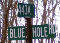
5. Keep your eyes peeled for Blue Hole Road on the right. If you reach a low-water bridge, you've gone too far. Blue Hole Road is a rough gravel road, but it's only a short distance to the parking lot.
Also nearby
Carson Hill Cemetery is the final resting place of Missouri Governor Mel Carnahan (1934-2000).
Facts
Names: Blue Hole; The Gulf
What: Sinkhole and underground lake
Location: Wayne County, Missouri
GPS coordinates: 37.0192, -90.6935
Topographic map: Mill Spring (where it is marked)
Owner: Mark Twain National Forest (purchased 1967)
See also: Geologic Wonders and Curiosities of Missouri
by Thomas R. Beveridge (second edition, 1990)
- Email link
- Read comments (2)
- Share:
Trip Planner

Respond to this blog
Posting a comment requires a subscription.