There's a lot of nature to explore in Southeast Missouri and its neighboring areas. Here's a look at just a few of the trails suitable for avid hikers, bikers and horse riders:
Hiking
Whether you're in the mood for a relaxing stroll or an invigorating trek, there's a trail for you in Southeast Missouri and the surrounding area.
> LaCroix Recreational Trail: The LaCroix Trail connects Cape Girardeau's Shawnee Park and the Osage Centre. The paved 4.42-mile trail is open to walkers, bicyclists, skaters, roller bladers and skate boarders. The trail can accessed at various points throughout the city and is open daily from 6 a.m. to 11 p.m.
> White Trace Trail: Located on the campus of the Cape Girardeau Conservation Nature Center, White Oak Trace features two miles of nature trails allowing visitors to traverse rolling river hills with sinkholes, deep hollows and ravines. Portions of the trail are handicap accessible, and benches line the route for those who want to stop and enjoy nature. Unpaved portions of the trail range from moderate to steep. It is open from sunrise to 10 p.m. daily. A map is available on the Nature Center's website, mdc.mo.gov/regions/southeast/cape-girardeau-conservation-nature-center.
> Tywappity Community Lake Trail: Tywappity Lake, a 37-acre body of water near Chaffee, Mo., was created in the 1950s as a lake for fishing. A 2.5-mile trail circles the lake, meandering near the water, then into the woods. A side trail near the northern edge of the lake connects to the Tywappity Towersite Conservation Area, climbing to the top of a ridge and providing views of the bottomlands west of Chaffee.
>Hickory Canyons Natural Area: Missouri isn't exactly famous for its canyons, but you can see the state's largest in Ste. Genevieve County. Two trails lead from the parking area in opposite directions. A short trail on the east side drops into a canyon and ends in front of a waterfall. A spur from the trail leads along the top of the canyon walls to the head of the waterfall. The second trail from the parking lot on the west side forms a loop that enters and exits a large canyon formed by Hickory Creek. The highlight of the trail is when it climbs a wooden staircase past a deep side canyon. This hollow, surrounded on three sides by ragged bluffs, features many ledges, overhangs and other assorted curiosities to explore.
> Ball Mill Resurgence: The Ball Mill Resurgence in Perry County is one of nature's oddities. Usually, it's just a regular sinkhole. During wet weather, however, enough water pressure builds underground to turn the sinkhole into a spring. It surges water, flooding the banks of a creek bed that is usually dry. A one-mile hike loops through the State Natural Area, passing several sinkholes in addition to the Ball Mill Resurgence. A parking area for the trail is off County Road 916.
Biking
Bicycling is great exercise and a great way to enjoy nature and the changing landscapes of Southeast Missouri and Southern Illinois. Slap on a helmet, grab some friends and head for one of these bike trails or routes. There are plenty of options, whether you're a casual rider or the next Lance Armstrong.
> Mississippi River Trail: This multistate route follows the Mississippi River from its headwaters in Minnesota to the Gulf of Mexico. It is comprised of about 3,000 miles of on-road bikeways and pedestrian and bicycle pathways. In Southeast Missouri, the trail is broken into segments -- Ste. Genevieve to Perryville, Perryville to Cape Girardeau, Cape Girardeau to East Prairie and East Prairie to Samburg, Tenn. Marked with MRT signs, the route takes you through the diverse landscape found in Southeast Missouri -- from Ozark foothills to delta floodplain -- and many river towns with a rich history. For more information on the Mississippi River Trail, go to www.mississippirivertrail.org/mo.
> Tunnel Hill State Rail Trail: This converted railroad bed is a popular destination for cyclists in Southeast Missouri and Southern Illinois. The trail runs for 45 miles from downtown Harrisburg to Karmak in Southern Illinois. The tail is managed by the Illinois Department of Natural Resources with an additional 2.5 miles managed by the city of Harrisburg. The central section of Tunnel Hill Trail passes through the Shawnee National Forest, Illinois' only national forest. The southern section of the trail traverses the Cache River State Natural Area, a significant state, national and international wetland resource. Added bonus: Because it is an old railbed, there's no hill steeper than a 3 percent grade. A popular route for local cyclists is an 18-mile round trip from Vienna, Ill., to Tunnel Hill.
> Klaus Park trail: This three-mile mountain bike trail in Cape Girardeau County has some short hills, making it good for beginners or advanced riders looking for a quick after-work jaunt.
> Cedar Lake Trail: Southern Illinois' Cedar Lake Trail is a popular destination for mountain bikers. The trail is a seven-mile loop that crosses rocks, creeks and a spillway. There are also some serious hills -- steep going up, fast going down. It can be combined with the Cove Hollow Trail, which adds eight miles round trip. Cove Hill, a rugged hiking trail, is more technical for bikers, featuring steep, rocky descents. Of course, it also offers spectacular views. For directions on how to access the trailheads, visit the Shawnee Mountain Bike Association's website, smbatrails.com/cedar.
> Velo Girardeau routes: OK, so it isn't a trail. But for bicycling enthusiasts, Velo Girardeau, Cape Girardeau's bicycling club, has a wealth of knowledge and opportunities available. Members meet for regular rides, offering a variety of distances and levels of difficulty. The schedule of events and routes is available on the club's website, www.velogirardeau.com.
Equestrian
Saddle up and hit the trail! Our region is home to a number of designated equestrian trails with varying lengths and terrain to suit your ability. If you're taking your horse across state lines, familiarize yourself with any laws or regulations that you need to follow. A negative coggins test is required for horses traveling between states.
> Castor River Conservation Area: This conservation area in Bollinger County is rugged. It is nearly all forest and is home to Blue Pond Natural Area. Horse riders are permitted on the 15-mile multiuse trail, and a horse campground is available at the trailhead.
> Giant City State Park, Makanda, Ill.: Giant City's 12-mile loop is a popular destination for local horse riders. The trail passes many of the park's trademark rock formations. The terrain ranges from steep hills to open meadows. A large portion of the trail is rocky, so make sure your horse has been shod before setting out. Campsites are available for horse owners, as well as a designated day-use area for trailers. There is no charge for day-use riders.
> Shawnee National Forest: The Shawnee National Forest covers a large area of Southern Illinois, and horse trails crisscross the forest's 280,000 acres. It has been voted one of the top five rides in the country by national trail riding magazines and attracts riders from near and far. With miles and miles of trails, there is plenty of variety to suit everyone from casual riders to advanced horsemen. Several commercial horse camps operate in and around the forest, providing easy access to the trails. Trailer lots are available near some trail heads for day riders. The trails pass some of the Shawnee Forest's best-known landmarks, including Indian Kitchen and the Garden of the Gods. A map, available from a camp or online at www.fs.usda.gov/main/shawnee/home, is essential for all riders. Many of the trails interconnect, and others are open only to hikers.
> Land Between the Lakes National Recreation Area, Golden Pond, Ky.: Land Between the Lakes Wranglers Camp is a trail rider's heaven. Nearly 100 miles of trails meander along lakeshores, through rolling meadows and peaceful forests. Some of the trails follow abandoned logging roads and are perfect for wagons. All of the LBL trails are clearly marked, and many connect with others to provide alternative routes. Enjoy a short six-mile ride before lunch, or pack some sandwiches and set out on an 18-mile ride. More information on the campground and trails is available at www.lbl.org/CAMPWranglers.
Sources: James Baughn's Pavement Ends blog, websites for Missouri State Parks, U.S. Forest Service, Missouri Department of Conservation, Illinois State Parks, Shawnee Mountain Bike Association, Velo Girardeau, Land Between the Lakes, Cape Girardeau County, Shawnee National Forest, Rails to Trails, Mississippi River Trail.
More trails
State parks in Missouri, Illinois and Kentucky are home to numerous trails suitable for hiking, biking and riding. Information about trails and individual parks is available online at mostateparks.com, www.dnr.illinois.gov and parks.ky.gov.
The Ozark Trail in Missouri and River to River Trail in Southern Illinois also are available for multiuse and connect to other trail systems. Information on these extensive trails is available at www.ozarktrail.com and www.rivertorivertrail.com.
Rules of the Trail
Whether you're on foot, wheel or hoof, there are some basic things to remember anytime you set out on a trail:
> Pack in, pack out: You should try to leave no trace of your presence on the trail. This means carrying out any trash, even things like orange peels and peanut shells you think will decompose. This also means leaving wildflowers, rocks and other natural items where you find them.
> Stick to the trail: Trails are laid out to minimize destruction of the natural area and have little impact on wildlife and vegetation. Avoid shortcuts or switchbacks, which can lead to erosion.
> Be considerate of other trail users. Many people on the trail want to enjoy the peace and solitude of nature. Be respectful of that.
> On trails where multiple use is permitted, hikers should stay to the right and yield to faster forms of transportation. Hikers, cyclists and ATV riders should always yield to horses.
> Follow posted trail rules. They are there to keep you safe as well as protect the environment.

 Local News 4/18/24Catholic Charities to hold ribbon-cutting for LifeHouse grand openingLifeHouse Crisis Maternity Home will provide education and support to pregnant women and new mothers at risk of homelessness. After 15 months of construction, the first resident will move in at the end of April. ...
 Local News 4/18/24Tenmile looks to add balcony to old Esquire Theater building1Cape Girardeau City Council approved a license and indemnity agreement with Tenmile Holdings LLC on Monday, April 15, for the installation of a marquee sign and awning with column posts for the old Esquire Theater building. ...
 Local News 4/18/24SEMO Orchestra to perform Elgar, Dvorak next week at River CampusThe Southeast Missouri State University Orchestra and guest cellist Julian Schwarz will present a two-piece program Tuesday, April 23, at the River Campus in Cape Girardeau. The concert will begin at 7:30 p.m. in Bedell Performance Hall, 518 S....
 Local News 4/18/24Police: Bollinger County woman told elaborate lies across multiple investigations, including sexual assaultBOLLINGER COUNTY — Police say a Bollinger County woman told several elaborate lies during sexual assault and harassment investigations in a complex and escalating scheme that targeted the mother of her fiance’s child. Michelle D. Kaempfer of Glen...
 Local News 4/18/24Jackson police, DEA host National Prescription Drug Take Back DayThe Jackson Police Department and Drug Enforcement Administration (DEA) will team up to host DEA’s National Prescription Drug Take Back Day on Saturday, April 27. The two organizations will collect different forms of prescription drugs. The...

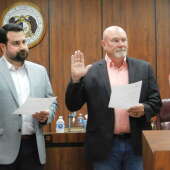


 Local News 4/16/24New Cape Girardeau City Council members sworn in; multiple appointments made to advisory boards3The Cape Girardeau City Council swore in new members and approved various appointments to multiple advisory boards Monday, April 15. New council members David Cantrell, Ward 4, and Rhett Pierce, Ward 5, took the oath of office at the meeting....
 Local News 4/16/24Fredericktown woman arrested in Cape on charges of stealing car, possessing drugs3Anna J. Dobyns, 40, is in the custody at the Cape Girardeau County jail in lieu of a $40,000 bond on charges of first-degree tampering with a motor vehicle, possession of a controlled substance and unlawful possession of drug paraphernalia. ...
 Local News 4/16/24Judge awards $23.5 million to undercover St. Louis officer beaten by colleagues during protest6ST. LOUIS — A St. Louis judge Monday awarded nearly $23.5 million to a former police officer who was beaten by colleagues while working undercover during a protest. Luther Hall was badly injured in the 2017 attack during one of several protests that...
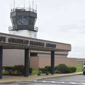 Local News 4/15/24Cape airport explores funding for possible new air traffic control tower12As Cape Girardeau Regional Airport’s construction projects move along, airport manager Katrina Amos and the Airport Advisory Board may start to look at possible funding options for a new air traffic control tower. Amos said the next big project on...
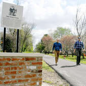 Local News 4/15/24Take a hike: Charleston introduces the town’s first trail — The Byrd WalkCHARLESTON — The late James L. "Jim" Byrd III loved his hometown of Charleston. He also loved trains. Now his family has combined those two loves to continue to grow Byrd’s legacy. With funds from Byrd’s estate, a new walking path was recently...


 Most read 4/12/24Notre Dame to transition to president/principal model beginning July 17Notre Dame Regional High School announced Monday, April 8, that it will be transitioning to a president/principal model Monday, July 1. Current principal Tim Garner will assume the role of president, while assistant principal Paul Unterreiner will...
 Most read 4/12/24Coroner still hasn't found attorney as Missouri AG seeks to remove him from office13More than two months after the Missouri Attorney General's Office filed court action to remove Cape Girardeau County Coroner Wavis Jordan from office, the local officeholder has still not found an attorney to help him fight to keep his job. Wavis...
 Most read 4/11/24Cape Girardeau woman accused of biting man for second time3Police arrived to a domestic disturbance call Tuesday, April 9, to find a man bleeding with a tennis ball-sized bite wound to his inner forearm. It allegedly wasn’t the first time. Colleen Ann Lewis, 53, was charged with third-degree assault. ...