

Pavement Ends
James Baughn was the webmaster of seMissourian.com and its sister newspapers for 20 years. On the side, he maintained even more sites, including Bridgehunter.com, LandmarkHunter.com, TheCapeRock.com, and Humorix. Baughn passed away in 2020 while doing one of the things he loved most: hiking in Southeast Missouri. Here is an archive of his writing about hiking and nature in our area.
- Email link
- Read comments (4)
- Share:


You won't find any flooding here
Posted Monday, April 7, 2008, at 3:47 PM
Finally, some nice weather is here (for now). I was looking for a good place to visit this weekend, but wanted to avoid floodwaters, road closed barricades, boggy fields, and other quagmires.
The answer is to seek higher ground. In this case, 1,772.68 feet above sea level. That's the elevation of the summit of Taum Sauk Mountain, the highest point in Missouri.
From the parking lot at Taum Sauk Mountain State Park, a short paved trail leads to the high point. The trail suddenly ends at this point:

How anticlimactic. Taum Sauk is more of a ridge than a mountain and has a relatively flat top. One rock looks about the same as any other. But this particular rock is slightly higher than the others, if only by a matter of inches.

Sitting in the middle of woods, you won't find a panaramic view from here. But there is an overlook from the park's access road.

A sign gives the names of all of the visible peaks from here. One of the largest is Buford Mountain, another flat-top mountain that rises to 1,740 feet and is only 32 feet shy of Taum Sauk.

Despite the wonderful view, the overlook only faces northward. If this is the highest point in the state, then where's the panoramic view? Well, you have to climb a fire tower for that.

The Taum Sauk Lookout Tower is the only place on the mountain that offers a 360-degree view.
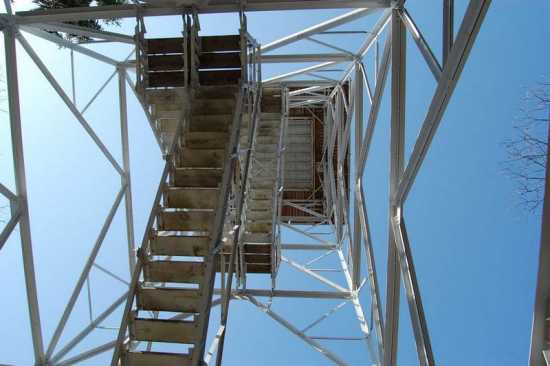
It's worth the climb, if you can stomach the journey up the steep, rickety steps.

Rugged terrain is visible in every direction. All of these peaks are part of the St. Francois Mountains, believed to have formed from volcanic activity over 1.4 billion years ago. That's many times older than the Appalachian and Rocky Mountains.
To the southwest, it's possible to glimpse the site of the Taum Sauk Reservoir disaster. Despite the name, the reservoir actually sits on Proffit Mountain. I suppose the folks at Union Electric thought that Taum Sauk had a better ring to it than "Proffit Plant."

The state park also features Mina Sauk Falls, the tallest waterfall in the state at 132 feet. The three-mile loop trail to the falls is rather rugged. When I visited a few years ago, the waterfall didn't have any flowing water, which made the hike a bust. However, it's probably flowing quite nicely this spring! I was losing daylight when I visited this weekend so I didn't try to hike to the falls.
Driving directions
&daddrFrom Cape Girardeau, take Highway 72 west through Jackson, Patton, and Fredericktown to Arcadia. At Arcadia, follow the signs for Highway 72 West and Highway 21 South. This road climbs into the hills and reaches Tip Top Roadside Park. Just after the park, turn right on Route CC and follow it until the road forks. The left fork goes to the lookout tower while the right fork leads to the parking lot for the high point. [Google map]
Quick facts
What: Taum Sauk Mountain
Claim to fame: Highest point in Missouri (1,772.68 feet above mean sea level)
Where: Iron County, Missouri, southwest of Arcadia and Ironton
Owner: Missouri Department of Natural Resources (Taum Sauk Mountain State Park created in 1991); fire tower owned by Missouri Department of Conservation (constructed 1949)
Designation: Part of St. Francois Mountains Natural Area
Topographic map: Ironton
GPS coordinates: 37.57128, -90.72908 (estimated -- I forgot to grab my GPS navigator when I visited)
- Email link
- Read comments (4)
- Share:
Trip Planner

Respond to this blog
Posting a comment requires a subscription.