

Pavement Ends
James Baughn was the webmaster of seMissourian.com and its sister newspapers for 20 years. On the side, he maintained even more sites, including Bridgehunter.com, LandmarkHunter.com, TheCapeRock.com, and Humorix. Baughn passed away in 2020 while doing one of the things he loved most: hiking in Southeast Missouri. Here is an archive of his writing about hiking and nature in our area.
- Email link
- Read comments (3)
- Share:


Go exploring in Cape County
Posted Thursday, June 21, 2007, at 12:10 PM
"STAY ON THE DESIGNATED TRAIL"
"DO NOT WALK ON THE GRASS"
"AREA CLOSED, NO TRESPASSING"
I hate seeing signs like these within parks and recreation areas. They might as well put up a sign that says "NO FUN ALLOWED."
One of the nice things about Missouri's extensive collection of state conservation areas is that you can just about go anywhere you want. Want to take a walk in a random direction? See what's behind that hill? Wade through a creek? Follow some animal tracks? No problem. (Just don't do anything stupid during hunting season.)
Apple Creek Conservation Area in northeastern Cape Girardeau County offers several parking areas where you can stop and then explore to your heart's content. It's a short drive from Cape and the area offers rugged hills, deep woods, and meadows filled with wildflowers.
And who knows what you might find around the next corner? Like this:

When I visited last weekend, I was surprised to see a large field planted with sunflowers. A handful were blooming. When the rest of the sunflowers bloom, this is going to be a spectacular sight.
The sunflower patch can be found by walking along a service road that leads west (left) from the parking lot at the Apple Creek boat ramp. Many other roads, trails, and paths criss-cross the 2,100 acre conservation area: But I'll leave that for you to explore.
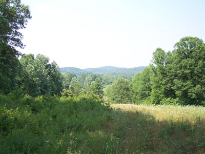
A meadow looking north toward the rugged hills of Perry County
Driving directions: The boring way
To reach Apple Creek Conservation Area, take I-55 north from Cape to the Fruitland exit, follow US 61 through Fruitland, turn right on Route C and continue to New Wells, and then turn right (twice) to head east on Route CC. After a few miles, look for the sign on the left that says "Apple Creek Fishing Access." This lane will take you to the boat ramp and parking lot. Be sure to pick up a map/brochure at the kiosk; this shows where the other parking lots and trails are located within the conservation area.
Or take the scenic route
Cape County features many miles of scenic gravel roads, especially in the northeastern corner. Instead of taking the interstate, you can approach from the other direction. It's a longer and slower drive, but much more interesting. Take Highway 177 north from Cape until you reach the P&G factory and then continue straight on Route J. This road turns into paved County Road 525 and passes through Neelys Landing.
Continue until you reach the intersection with County Road 535 on the right. This gravel road eventually reaches Route CC and the conservation area. It's a scenic backroad that climbs United States Hill, wanders across Dog Hollow, passes over another hill, crosses Lovejoy Creek, meanders along the ridge at High Hill, and finally drops into a hollow and crosses a small creek on a quaint wooden bridge. The road is steep and curvy, but that's part of the fun.

Driving down High Hill

Low water bridge over Dog Creek
Or take the even more scenic route
If that's not enough, then try exploring County Road 532. It meets CR 535 about half-way between Neelys Landing and Route CC, just north of the bridge over Lovejoy Creek. It runs southwest and eventually reaches Pocahontas. At first this looks like another gravel road. But the sign that says "IMPASSABLE DURING HIGH WATER" is not kidding.
This part of the road, if you can call it a road, drops into Lovejoy Creek and stays within the creek bed for nearly three-quarters of a mile. Nature provided a flat-bottomed gravel creek, and the county has taken advantage of this natural roadbed. But I wouldn't want to be here in low water, much less high water.

The photos don't do this place justice. This is not a road, it's a creek, with steep banks on either side and a driving surface consisting of large, uneven rocks.

It's not for the faint of heart. But where else can you drive down the middle of a creek without trespassing?
- Email link
- Read comments (3)
- Share:
Trip Planner

Respond to this blog
Posting a comment requires a subscription.