

Pavement Ends
James Baughn was the webmaster of seMissourian.com and its sister newspapers for 20 years. On the side, he maintained even more sites, including Bridgehunter.com, LandmarkHunter.com, TheCapeRock.com, and Humorix. Baughn passed away in 2020 while doing one of the things he loved most: hiking in Southeast Missouri. Here is an archive of his writing about hiking and nature in our area.
- Email link
- Read comments (5)
- Share:


Visit the Illinois version of the Grand Canyon
Posted Wednesday, October 8, 2008, at 12:05 PM

The Little Grand Canyon near Murphysboro, Illinois, isn't quite as large as its namesake in Arizona. In fact, it's probably only 0.0001% the size. But it's still an impressive canyon by Midwestern standards.
Since the canyon is surrounded by bluffs and the Big Muddy River, there is no easy access. But that's half the fun.
A challenging 3-mile loop trail enters and exits the canyon. You can hike either direction, but the counter-clockwise route (taking the trailhead on the right at the parking area) offers the best instant gratification by reaching the canyon sooner.
Starting out, the trail descends slowly through the woods toward the canyon. Then it abruptly reaches an overlook of the canyon:

The trail follows a switchback to the left and then reaches the head of a small side canyon. Here's where it gets interesting:
From above, the canyon looks steep and slippery. Don't panic... Steps have been conveniently carved into the rocks:

It's just a matter of finding the footholds and playing "Follow the Breadcrumbs" as you carefully climb down the rocks. Soon you'll see the main canyon below:

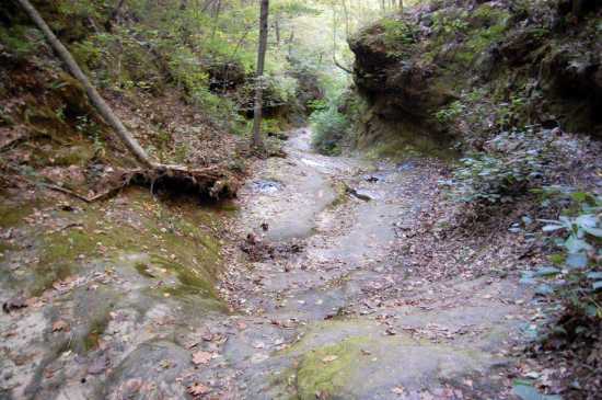
Welcome to the Little Grand Canyon. Looking back up the entrance, it's hard to believe you just traversed these rocks:

At the valley floor, the trail turns left and goes downstream through the main canyon. Before that, however, turn right and take a short trail spur up the canyon. It goes past a huge rock shelter:

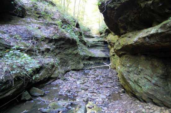
Finally, the trail ends at the impassible head of the canyon:
After returning to the main trail, it's time to choose an "exit strategy." Either way, you will need to climb up a side canyon using the footholds. You can go back the way you came in, or continue on the trail to another side canyon exit.
If you choose to continue, the trail meanders down the canyon to where it meets the Big Muddy River. The river is big and muddy, but the trail veers left, bypassing the mud. It soon reaches the exit:

Footholds are also available here. However, when I visited, this other canyon had more flowing water and was rather slippery.
At the top, the trail veers to the right and eventually reaches an overlook of the Mississippi River floodplain. It then switches back to the left and follows the crest of "Viney Ridge" before reaching the parking lot.
Caution: While it's tempting to walk to the edge of the overlooks for a better view, that's not a good idea. In September, a hiker ventured too close to the edge and fell to his death. Also, this year has seen at least two rescues after visitors were injured in the canyon and couldn't climb out. So don't do anything stupid!
Driving directions
From Cape Girardeau, cross the Emerson Bridge and follow Highway 146 towards Jonesboro, making a left at Highway 3 and then a right at McClure. Before reaching Jonesboro, turn left on Highway 127 toward Alto Pass and Murphysboro. Go 16 miles and look for the turnoff for Etherton Road on the left. Continue on Etherton Road as it turns into Poplar Ridge Road and then Hickory Ridge Road. The turnoff for Little Grand Canyon Road will be on the right at a sharp curve. The parking area is just down this road.
You should see guide signs for Little Grand Canyon, but remember this is Illinois, the Land of Missing Road Signs. Getting lost in Illinois is about as easy as falling off a log. Indeed, one of the residents along Hickory Ridge Road has erected a mock headstone with the words, "Here lies the last bastard who stopped for directions." Enough said.
Quick facts
Name: Little Grand Canyon
What: Box canyon with sheer bluffs and a challenging hiking trail
Where: Jackson County, Illinois, southwest of Murphysboro
Owner: Shawnee National Forest
GPS coordinates: 37.68025, -89.39510 (parking area)
Topographic map: Gorham
Links: Trail map; PDF brochure
- Email link
- Read comments (5)
- Share:
Trip Planner

Respond to this blog
Posting a comment requires a subscription.